


Ski Arena Szrenica
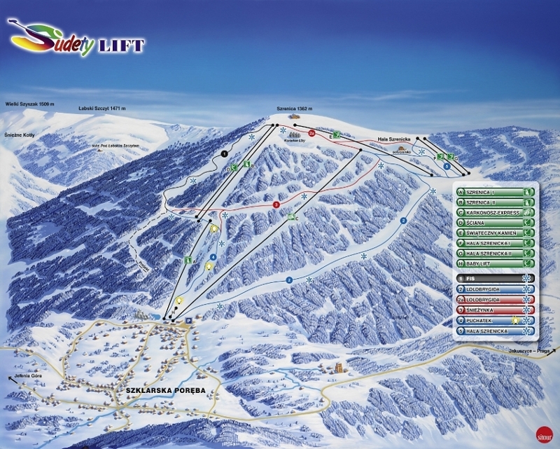
property SUDETY LIFT Sp. z o.o. Szklarska Poręba www.sudetylift.com.pl
- FIS downhill route
very difficult route
length of 2000 m
510 m level difference
average gradient of 25.5%
greatest slope gradient of 50.0% (wall)
the width of Route 30 - 50 m
location of the beginning 1302 m above sea-level route
location of the end of the route 792 m above sea level, where access to the lower K.L. station is available
SZRENICA forest road - 1 km
Installation of artificial snow 80% of the route, from 850 m above sea level to 1225 m above sea-level
- LOLOBRYGIDA Cross country ski run
difficult route
length of 4400 m
602 m level difference
average gradient of 14.0%
greatest slope of 36.0%
width of the route from 1915 to 1945 m
location of the beginning 1310 m above sea-level route
location of the end of the route 708 m above sea-level
installation of artificial snow 88% of the route, from 708 m to 1200 m above sea level
- ŚNIEŻYNKA Cross country ski run
difficult route
length of 2080 m
300 m level difference
average gradient of 15%
greatest slope of 45% ('eses')
width of the route from 1915 to 1935 m
location of the beginning 1182 m above sea-level route
location of the end 882 m above sea-level route
installation of artificial snow 100% of the routes
- POOH Cross country ski run
a simple route
length of 1470 m
level difference of 172 m
average gradient of 12.0%
greatest slope of 27.0%
width of the route from 1915 to 1935 m
location of the beginning of the route 880 m above sea-level
location of the end of the route 708 m above sea-level
installation of artificial snow 100% of the routes
installation of artificial light 100% of the route
- "SZRENICKA ALP" The slope slalom
length of 650 m
120 m level difference
average gradient of 18.5%
greatest slope of 25.5%
width of the slope 100 - 200 m
location of the beginning of the route 1280 m above sea-level
location of the end of the route 1160 m above sea-level
